Table of Contents
Rivers of India Important Facts:
The Indus System:
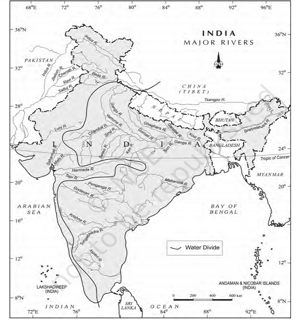
Indus:
- also known as sindhu.
- Westernmost Himalayan river.
- Originate from a glacier near Bokhar chu in Tibet region.
- it enters India in the ladakh district of J&K.
- Mountain range – Kailash.
- in Tibet, Indus is known as Singi Khamban or Lion’s mouth.
- Several tributaries like the Zaskar, the Nubra, the Shyok & the Hunza join it in the Kashmir region.
Tributaries of Indus:
- Jhelum – rises from a spring at Verinag in Kashmir valley. Then it flows into Wular Lake where Kishenganga project is located.
- Chenab – largest tributary of the Indus. Formed by two streams, the Chandra & the Bagha, which join at Tandi near keylong in Himachal Pradesh.
- Ravi – originate at Rohtang pass near Himachal Pradesh.
- Beas – originate at Beas kund near Rohtang pass in Himachal Pradesh.
- Satluj – originate at Rakas lake in Tibet. It enters H.P. at Shipki La. It is an antecedent river.
Ghagghar-Hakra – It originates at Ambala & loses in the desert in Hanumangarh.

The Ganga System:
- Largest, longest , national , holliest river of India.
- Originate as Bhagirathi from gangotri glacier near Gaumukh & is called as Ganga only when Alaknanda joins it at Devprayag.
Tributaries of Ganga:
- Yamuna – Largest & most important tributary of Ganga. Rises from Yamunotri glacier in Uttarakhand. Joins Ganga at Prayag (Allahabad). Tributaries – Chambal – originate at Mhow Cantt, Indore. Joins Yamuna at Itawah. Cuts a gorge ; Ken – Originates in Malwa plateau, makes a gorge, joins Yamuna at Banda, UP. ; Sind ; Betwa.
- Son – Only tributary of Ganga from south. It joins Ganga directly. Originates at Amarkantak in Chattisgarh. It is an example of radial drainage & centrifugal drainage in India.
- Ghaghra – It originates in Nepal, cuts a gorge and joins Ganga near Chapra. Antecedent. Kali – Also called Sharda, originates in Nepal and meets Ghaghra at Barabanki.
- Gandak – Enters India at Champaran and meets Ganga at Sonpur near Patna.
- Kosi: It joins Ganga at Manihari. Originates at Mt. Everest.
The Brahmaputra River System:
The Brahmaputra rises in Tibet east of Mansarowar lake very close to the sources of the Indus and the Satluj. It is slightly longer than the Indus, and most of its course lies outside India. It flows eastwards parallel to the Himalayas.
U-Turn or the Great Bend of Brahamputra:
- On reaching the Namcha Barwa (7757 m), it takes a ‘U’ turn and enters (it is due to syntaxial bending of the Himalaya) India in Arunachal Pradesh through a gorge.
- Here, it is called the Dihang and it is joined by the Dibang, the Lohit, and many other tributaries to form the Brahmaputra in Assam.
- In Tibet the river carries a smaller volume of water and less silt as it is a cold and a dry area.
- In India it passes through a region of high rainfall. Here the river carries a large volume of water and considerable amount of silt.
Brahamputra as a Braided Channel:
- The Brahmaputra has a braided channel in its entire length in Assam and forms many riverine islands.
- (Majuli is the largest river island in the world) Every year during the rainy season, the river overflows its banks, causing widespread devastation due to floods in Assam and Bangladesh.
- Braided Streams occur in rivers with high slope and/or large sediment load.
- Braided channels are also typical of environments that dramatically decrease channel depth, and consequently channel velocity, such as river deltas, alluvial fans and peneplains.
Why Brahmaputra shifts its path frequently?
- Unlike other north Indian rivers the Brahmaputra is marked by huge deposits of silt on its bed causing the river bed to rise.
- The river also shifts its channel frequently.
River System of the Peninsular Drainage:
- Luni: Originates at Ajmer, drains west of Aravalis and merges into Rann of Kuchch.
- Sabarmati: Drains south Aravalis into Gulf of Khambat.
- Mahi: Originates in Vindhyan hills. Drains into Gulf of Khambat.
- Narmada: Originates at Amarkantak in Maikal hills in Chattisgarh. Flows into Gulf of Khambat. Makes an estuary near Bharuch. 1300 km. Flow through rift valley between the satpura in the south & the Vindhyan range in the north. Sardar sarovar project constructed on this river.
- Tapi: It rises in Satpura hills. Makes an estuary near Surat. 725 km. Flow through rift valley.
- Subernrekha: Rises near Ranchi and flows east into Bay of Bengal (BOB).
- Brahmani: It merges into Mahanadi and flows into BoB at Paradip port. Its tributaries Koel and Sankh join at Rourkela.
- Mahanadi: It rises in Chattisgarh, Hirakud dam is built at the gorge where it turns right. Meets BoB at Cuttack. 850 km.
- Godavari: Rises in Nasik at Western Ghats. 1465 km.
- Krishna: Originates in Mahabaleshwar. 1400 km.
- Pennar: Rises in Kolar.
- Cauveri: It rises in South Mysore plateau and near Mysore Krishna Sagar dam has been built. 800 km.


Comments (No)